- Islands really can disappear off the face of the Earth, especially if they never exist in the first place.
Ghostly islands that appear out of the ocean mists only to disappear again are a staple of maritime stories. It’s no wonder, either, considering such islands really existed.
Kind of.
Phantom islands are a maritime phenomenon where a sailor, having seen something, marks an island or continent on a map. However, when others later sail by, they never find anything.
Despite it all, phantom islands can stay on official maps for decades or even centuries. Here are 9 examples of phantom islands and the strange truths behind them.
1. Brasil
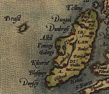
No, we’re not talking about the South American country. Brasil or Hy-Brasil is a legendary island in Irish folklore, supposedly located in the Atlantic west of the Emerald Isle.
Since the Middle Ages, Brasil regularly appeared on maps, although nobody ever seemed to know exactly where it was, since its location was always different. Many explorers claimed to have visited the island and gave varying accounts of what’s there, but the stories usually involved at least one wizard.
In reality, there is no island west of Ireland that could be Brasil. The mythical island may refer to Rockall, a large granite boulder sticking out of the ocean that, from a distance, may look like a sky-high island.
2. Bermeja
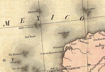
Multiple maps drawn between the 16th and 20th centuries show a small island called Bermeja located southwest of Mexico’s Yucatan Peninsula. Unlike most phantom islands, its location on the old maps is remarkably consistent.
This consistency led people to believe for centuries that Bermeja really exists. However, extensive modern studies in 1997 and 2009 have found no trace of the island.
Consequently, researchers and conspiracy theorists alike have suggested that Bermeja really did once exist but has since been destroyed. Some posit that a volcanic eruption sank the island, while some fringe theories state the CIA blew it up to defend U.S. oil claims.
3. Isle Phelipeaux
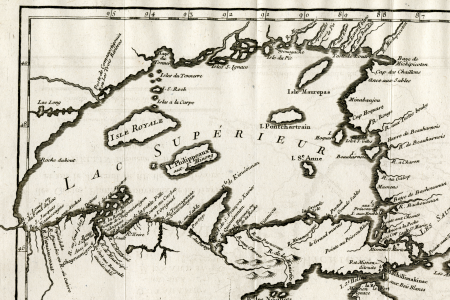
Not all phantom islands are out on the ocean. Isle Phelipeaux was supposedly located in Lake Superior.
It was first placed on maps in the late 18th century and stayed there until the 1900s. The island allegedly sat southeast of the real Isle Royale.
As you might know, in reality, there are no islands between Isle Royale and Michigan’s Upper Peninsula. Isle Phelipeaux is likely a case of double reporting of Isle Royale or a mistaken identification of the Upper Peninsula shoreline.
4. Frisland
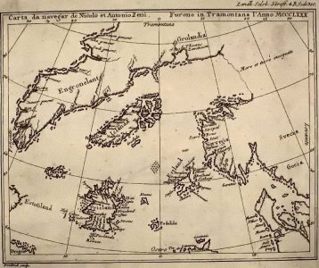
In 1558, Venetian statesman Nicolo Zeno the Younger drafted a world map based on travel notes written by his ancestors Nicolo and Antonio Zeno in the 14th century. Based on these notes, he placed an island called Frisland south of Iceland.
No one seems to have questioned Zeno, since Frisland appeared on virtually all North Atlantic maps until the late 1660s. At that point, increased exploration of the region showed that the island didn’t exist.
But why did Zeno include it, then? Well, the answer is simple — his entire map was made up.
Although Nicolo and Antonio Zeno existed, they likely never traveled as extensively as Nico the Younger claimed. He either seriously misinterpreted their notes or was just pulling stuff out of his ***.
5. Sandy Island
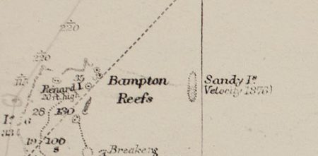
Sometimes nonexistent islands can stay on maps for a really, really long time. Take, for instance, Sandy Island, which was supposedly located northeast of Australia near the French territory of New Caledonia.
The first person to find Sandy Island was none other than the famed explorer, Captain James Cook. In 1774, he marked “Sandy I.” on a map he was drawing.
What Cook actually saw is not clear, but Sandy Island does not exist. Yet, it took more than two centuries before it was finally taken off the maps.
In 1974, on the 200th anniversary of Sandy Island’s discovery, Sandy Island disappeared from French nautical charts. Yet, it wasn’t until 2012 that an Australian research ship conclusively “undiscovered” Sandy Island.
6. Isle of Demons
Some phantom islands make it onto the maps simply because people think they know it’s there. A great example of this is the Isle of Demons off the coast of Newfoundland.
The Isle of Demons has its origins in Native American folklore, which describes an island inhabited by evil spirits. Western explorers and settlers never questioned its existence and started placing the demon-infested island on maps in the early 16th century.
However, nobody knew where exactly the island was, and its location changed with every map. Eventually, in the late 17th century, somebody figured out that the demon island didn’t exist and dropped it off the maps.
Yet, in 1541, French noblewoman Marguerite de La Rocque was marooned on the “Isle of Demons.” What island it really was is anyone’s guess, but you can read more about Marguerite in our list of 6 incredible castaway stories.
7. St. Brendan’s Island
The year is somewhere around 512, and St. Brendan the Navigator leaves Ireland on an exploration journey around the world. West of northern Africa, he discovers an island with bountiful vegetation, where he preaches the gospel to the native inhabitants.
As the story was written down in the ninth century, the place was called St. Brendan’s Island. So, where is it?
Nowhere. Although St. Brendan existed and he may have embarked on a daring journey, he certainly never reached the mysterious island named after him. Yet, up to the 18th century, more than 1,000 years after his supposed trip, sailors kept claiming they’d seen St. Brendan’s Island and placing it on maps.
8. New South Greenland
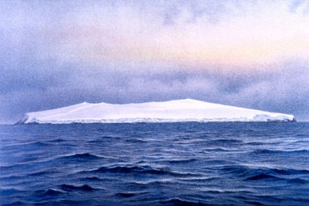
Benjamin Morrell (1795-1839) was an American sea captain and explorer. In 1823, he saw and mapped a large island off the Antarctic Peninsula, which he dubbed New South Greenland.
Nobody sailing through the area has seen this island since. What on earth could have made Morrell think he saw a large, uninhabited island?
Well, there are some theories. He may have seen an enormous floating iceberg that he mistook for solid land. Alternatively, he may have witnessed a mirage, common in the Antarctic seas, that he identified as an island.
That, or he just made it up. Morrell was infamous for coming up with nonsensical details to make his voyages seem more fantastic, so it might be that he dreamed up New South Greenland to go down in history as the discoverer of a new land.
9. Thompson Island
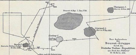
Finally, we have Thompson Island. This tiny scrap of land was supposedly located in the South Atlantic, almost smack-dab in the middle between South America and South Africa.
Whaling ship captain George Norris first reported the island in 1825. Following its discovery, Thompson Island appeared on maps until the 1950s — despite no one ever finding it again.
Thompson Island’s mysterious disappearance led scientists to theorize that an underwater volcanic eruption had either blown it up or caused the ocean to swallow it. That sounds reasonable, right?
Yet, a 1997 survey of Thompson Island’s reported location found that the ocean is more than 7,900 feet deep at the spot. There is no undersea volcano that could have destroyed the island, so it likely never existed at all.