- Birds really do see a whole different world.
Are you really bored and can’t think of anything to do? Here’s a fun way to pass the time: go on Google Maps, turn on satellite imaging, and start looking around.
You’d be surprised at how many strange things you can find. And you’d never even know they’re there if you weren’t looking down from the air.
Here are 10 bizarre structures you can spot on Google Maps.
1. Galesnjak
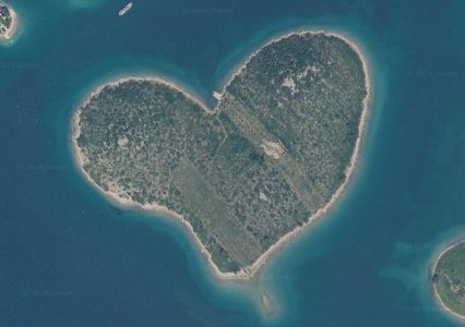
Off the coast of Croatia, in the Adriatic Sea, you can see Galesnjak. This small island is famous for being shaped like a heart.
Its unusual shape was first discovered by French cartographer Charles-François Beautemps-Beaupré in the early 19th century. Of course, the island had been heart-shaped before that, but nobody had realized it.
Thanks to its shape, Galesnjak is also known as Lovers’ Island and is a popular destination for couples.
See it here.
2. Hungary’s Roundabout to Nowhere
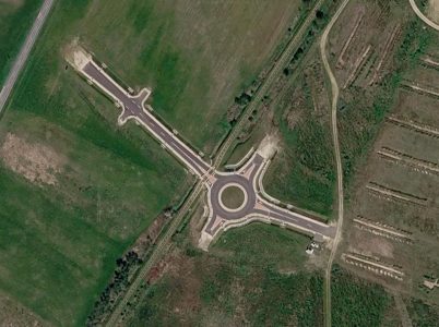
In western Hungary, near the city of Zalaegerszeg, lies one of the most bizarre traffic solutions you’ve ever seen. It’s a modern, multilane roundabout — that’s not connected to anything.
The piece of pavement was built in 2023 at a cost of about $1.25 million. It was supposed to be part of a new business and logistics center.
However, the project hit a snag and hasn’t continued since. Now, the roundabout is there, but no one is able to drive through it.
See it here.
3. New Mexico Desert Swastika
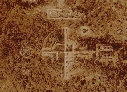
South of the city of Roswell, in the middle of the New Mexico desert, is an eerie sight. An enormous swastika has been carved into the sand, surrounded by a number of other eldritch symbols.
Considering Roswell’s extraterrestrial reputation, you might think the symbol is the work of alien nazis or something. However, it — along with the other markings — is part of a WWII-era training range for bomber aircraft.
The military figured the plane crews would be more motivated if they had a big swastika to aim for.
See it here.
4. Adrar Madet Stone Circle
Here’s another strange symbol surrounded by nothing but desert. In the depths of the Nigerien Sahara is a strange, black stone circle, roughly 70 feet in diameter.
The thing is, nobody’s sure why it’s there. Some archeologists suggest it could be a prehistoric structure, while others believe it’s a navigation aid for pre-GPS airplane pilots.
See it here.
5. Ocean Planes
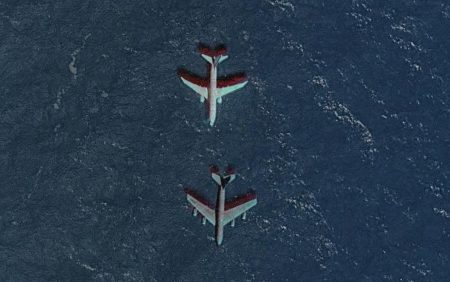
Not all weird sights on Google Maps are created intentionally. Off the coast of Oregon, you can spot two large airliners flying dangerously close to each other.
In reality, however, these planes probably never were in the same place at the same time. The situation you see on Google Maps is most likely a result of planes getting caught on satellite images that were then stitched together, making it seem like they’re flying together.
See it here.
6. Kamchatka Cross
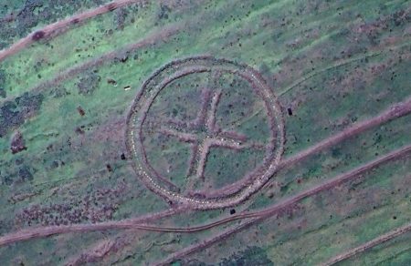
On the remote shores of the Kamchatka Peninsula in the Russian Far East is a mysterious symbol. Within a 350-foot-wide circle is a small cross, situated in the middle of nowhere.
No one knows for sure what the thing is, but it is (or was) most likely used as some kind of airborne navigation or calibrating guide. It could be a bombing target, being Russia’s equivalent of the Roswell swastika, or it may have been used to hone the targeting mechanisms of Soviet missiles.
See it here.
7. Frozen Planewreck
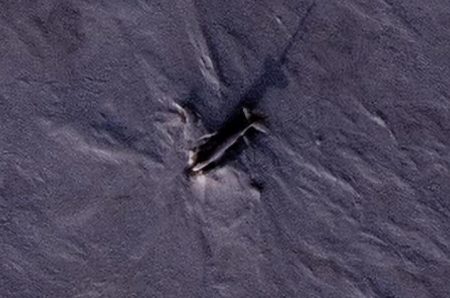
In the far reaches of Canada’s northernmost Nunavut province, on Ellef Ringnes Island, lies a memorial to an old airplane accident. In the remote wilderness sits the nose-down wreck of a Douglas C-47 Skytrain airplane.
The cargo plane came down in 1949 in adverse weather conditions. In a stroke of incredible luck, not one of its 10-man crew died in the crash.
The area’s frigid climate has frozen the plane in time and place, preserving it as a reminder of how dangerous flying in the far north can be.
See it here.
8. Lagoa do Gigante Humanoide
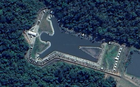
This is a fun one! Some 200 miles northwest of the Brazilian city of São Paulo, surrounded by endless farmland, is a man-shaped lake.
It’s very obviously intentionally built, but why it’s there is a bit of a mystery. It’s located in a “recreational area” but is not open to the public. So what’s its purpose?
See it here.
9. Lun-Class Ekranoplan
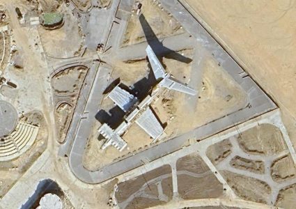
In 1987, the Soviet Union developed something of an ultimate weapon: the Lun-class ekranoplan. This enormous half-airplane, half-ship behemoth could transport cargo, launch missiles, and haul troops, all the while being virtually invisible to late-Cold War radars.
The thing served the Soviet and then Russian navy into the 1990s until it was decommissioned. Today, the hulking machine sits as a museum ship on the shores of the Caspian Sea. It’s so huge you can easily see it on Google Maps.
See it here.
Oh, and if you want to read more about the ekranoplan, check out our list of 8 bizarre Cold War plots.
10. 2,000-year-old Earthworks
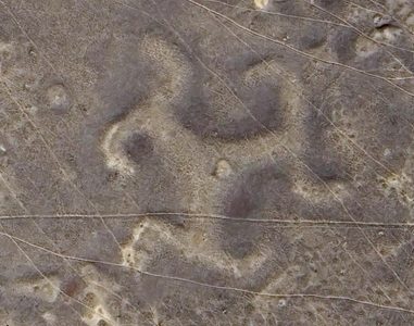
You’d imagine that building enormous structures that are only really visible from the air would be a recent phenomenon. However, people have been doing it since time immemorial, as this 2,000-year-old triskelion earth mound in Kazakhstan demonstrates.
The carefully shaped mound is almost 300 feet in diameter, rising high into the air. But the thing is, its presence isn’t really that obvious on the ground level.
You can really only appreciate it from a plane or satellite images — which the ancient Kazakhs obviously didn’t have. So how and why did they build it? What a mystery.
See it here.
Want some more Google Maps oddness? Check out our previous list of strange map objects!